Nilambur railway station. Photo by- Vighnesh K
The tree ‘Teak’ comes to the mind of any Keralite when they hear the name ‘Nilambur’! Nilambur teak is the first forest species to receive Geographical Indication (GI) status. Geographical indication is a tag which helps to identify the place of origin, quality, reputation or other characteristics of products that are unique to the place.
Nilambur teak is a unique variety and most important timber tree in India. Its durability and quality gave it a reputation in the world timber market. Nilambur hosts one of the oldest teak plantations and preserved it as permanent plot in the ‘Cannolly plot’. The original teak plantation in the Cannolly plot started in 1846 – hosting one million trees over 607 ha. In present day, it has shrunk to 2.3 ha. A museum focusing on teak was also established in Nilambur in 1995. Teak (Tectona grandis) is a deciduous tree in the family Lamiaceae. The flowers are small-white in colour, with a fragrance which forms dense clusters at the end of branches. The leaves are large with hairy lower surfaces. The durability and water resistant properties of the wood is favorable for making furniture and other wood products. It is widely used for ship building and manufacturing yatchs. It has been used even in the Kaaba mosque in Mecca, the Titanic ship, and the interiors of Rolls Royce cars etc.
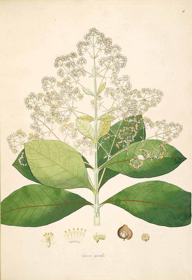
Illustration of Tectonagrandis {205|1289Roxburgh, W., Plants of the coast of Coromandel (1795-1819)}
Tectona grandis is native to South and South-East Asia. There are two genetic origins of teak- one in India and other in Myanmar and Laos. The locals perceive that the golden brown colour of Nilambur teak is due to the presence of gold absorbed from the Chaliyar River. Nilambur teaks are obtained from natural forests and teak plantations in the region. It is believed that the Nilambur- Shornur railway was constructed by the Britishers to transport teak from Nilambur.
The local people’s perspective on Teak
I interviewed two people who reside in Nilambur – close to the forest. I asked them about their relation with the teak tree, the stories they have heard about it, the current status and their opinion.
Person 1: From Arnadan indigenous community who lives close to forest and visits forest often.
“I collect fallen teak branches to use as firewood. It is the best as it burns easily and like a flame on a stove. Furniture is also made from the wood of the tree. I had also collected teak seeds from the plantations for outsiders to grow them in their nursery… As far as I know, teak is a plantation crop and was introduced here by the British. I think it needs good sunlight to grow as I don’t see teak growing everywhere and is rare sight in the forest… It is usually hot when we are close to the plantations or under the teak tree. The bark of the tree is eaten by elephants and seeds are eaten by termites. However, I don’t see any birds eating the fruit. Honey bees build their hives on the teak trees- both in the holes and big branches giving us an opportunity to harvest honey… I have seen teak trees on Mysore road also, but definitely they are a decoration to Nilambur.”
Person 2: From Kattunaikka indigenous community. Works in timber depot and visits forest more often.
“For me, teak means livelihood. I work in the depot – helping in lifting and moving the woods. It is a seasonal job. Tender is given in particular months by the government. My father used to work in plantations too. He used to cut, plant, de-weed and help in putting fertilizers. We use teak to build sheds and as firewood as well. Since we don’t store firewood; teak is the preferred wood in rainy season – as it burns easily… After an age plantations get cut and removed unlike natural forests. The new plantations are not very successful. Authorities are unable to prevent elephants from damaging the saplings and juvenile trees and preventing other forest plants from taking over. The number of teak trees in Nilambur is decreasing. Once they cut all the teaks; best is to leave the plantations to naturally re-generate natural forest back. Yes, it will affect our livelihoods- but we also depend on the forests for a livelihood… Known for the best quality teak, Nilambur has become popular because of the tree. The second best according to me, is ‘Ranni teak’. Since the new planting activities are a failure and the number of teak trees in Nilambur is decreasing*, we need to prevent teak from disappearing in Nilambur. What we are doing now may be not the step for it. Protecting the remaining teaks may be the way.”
*The productivity of teak plantations in Kerala is decreasing –
{https://www.downtoearth.org.in/coverage/fall-of-the-paragon-34341}
By Asish M
References:
- https://en.wikipedia.org/wiki/Teak
- https://www.downtoearth.org.in/coverage/fall-of-the-paragon-34341
- http://www.forest.kerala.gov.in/index.php/about-us/forest-dept-history
- https://www.newindianexpress.com/states/kerala/2018/jan/01/geographical-indication-tag-famed-nilambur-teak-is-now-keralas-own-1741369.html
- http://www.teaknet.org/download/teaknet2014/Session%20II/conf_10.pdf
- Roxburgh, W., Plants of the coast of Coromandel (1795-1819)